In June of 2010, the State of Maine Navigational Aids Team completed the installation of 72 buoys on Little Sebago Lake marking various hazards, shallow areas, reduced speed zones, and channels. These buoys are maintained by the State and remain in the water year round. This project is a work in progress and the Navigational Aids Team is available to answer questions, look at other areas, and make changes as necessary.
Facts about the Navigational Aids Program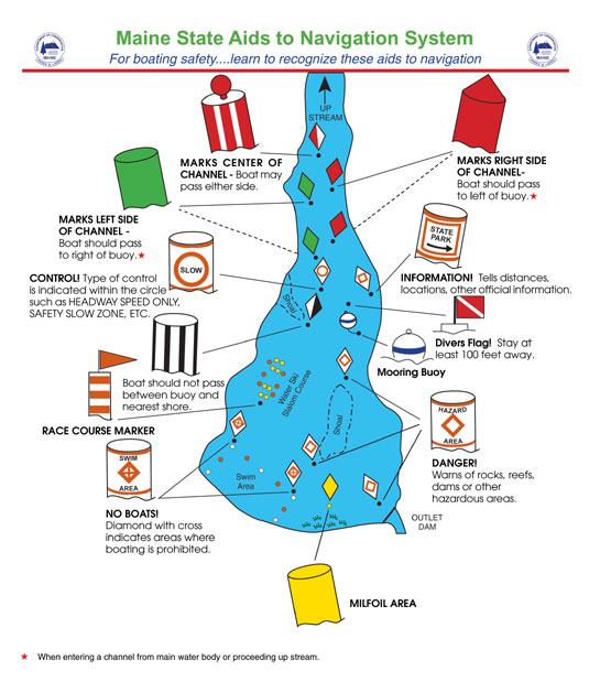
- It’s run by a 3 person team
- The program follows nationwide marking system for state waters
- The team covers 40 lakes here in Maine with 2,640 buoys
- As of 2025, Little Sebago Lake has 75 navigational and regulatory markers
- Buoys are documented on the State of Maine website.
- NOTE: there are a number of “Slow” and “No Wake” buoys not placed by the State, as well as some “Swim Area” buoys. There are specific requirements for these to be legal, such as permits and compliance with recent laws. Please be aware of this as any buoys not in compliance may be removed.
Criteria for Marker Placement
Hazard – any obstruction to navigation submerged in or floating on the waters of this State occurring
either naturally or placed in or on the waters by individuals.
- More than 200’ from shore
- Exceptions for channels and specific high traffic areas
- Covered by less than 4’ of water during boating season
Headway Speed – the slowest speed at which a vessel can maintain steerage (steering control). It’s the minimum speed necessary to keep the boat moving forward and controllable, essentially the “barely moving” speed. This is often equivalent to a “no wake” speed, meaning the boat should not be creating a noticeable wake.
- The marker should be in the interest of boating safety
- The marker should reduce the need for on-site enforcement of the headway speed law
- The area should clearly be a headway speed zone
- The area across for the marker placement can not be less than 250 feet wide or greater than 400 feet wide
Other Noteworthy State Rules
Moorings
- Must be located within 200 feet of shore or 1/3 the distance to the opposite shore, whichever is less
- Can not block a channel, or a fairway, or a public boat access site
- Can not deny the right of free navigation
- Should be a white ball with a blue stripe
Docks, swim floats, trampolines, rubber duckies, etc.
- Must be located within 200 fet of shore or 1/3 the distance to the opposite shore, whichever is less
NOTE: Maine State Rules are the minimum. Local municipalities may have further rules.
For more information: https://www.maine.gov/dacf/parks/water_activities/boating/navigational_aids.shtml
The LSLA Navigational Guide
The LSLA has developed a Navigational Guide that we hope will be helpful to all who use the lake. This shows how to navigate through both narrows as well as how to read the buoys. It’s full of useful information pertaining to Little Sebago Lake. The guides have been printed and copies are available from the Patrol Boat as well as electronically by clicking here.
Any questions may be sent to info@littlesebagolake.com.